| Language of origin | Athabaskan-Eyak-Tlingit, Na-Dene language family Tŝilhqot’in language |
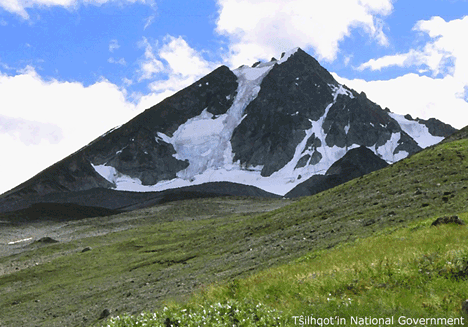
| Feature Type: | Mountain - Mass of land prominently elevated above the surrounding terrain, bounded by steep slopes and rising to a summit and/or peaks. |
| Status: | Official |
| Other Names: | Mount Tatlow |
| Name Authority: | BC Geographical Names Office |
| Relative Location: | E side of Tŝilhqox Biny (lake) S of the Nemaiah Valley, Lillooet Land District |
| Tags: | Indigenous |
| Latitude-Longitude: | 51°22'20"N, 123°51'48"W at the approximate centre of this feature. |
| Datum: | WGS84 |
| NTS Map: | 92O/5 |
|
Origin Notes and History:
|
"Mount Tatlow" adopted 26 June 1911 on Ottawa file OBF 0024, as submitted 23 June 1910 by BCLS, Vancouver. Name changed 11 March 2019 to Tŝ'ilʔoŝ as recommended by Tŝilhqot’in National Government as Tŝ'ilʔoŝ is the Tŝilhqot’in name for this mountain and supported by the Cariboo Regional District, BC Parks, Avalanche Canda, and Recreation Sites and Trails. Source: BC place name cards & correspondence, and/or research by BC Chief Geographer & Geographical Names Office staff. |
|
Tŝilhqot’in proper noun. Sometimes written as Tŝ’ilʔoŝ Dẑelh, meaning 'Tŝ’ilʔoŝ mountain.' Occasionally spelled "Tŝ’ilʔuŝ" (Advice from Tŝilhqot’in National Government, 2018). Source: BC place name cards & correspondence, and/or research by BC Chief Geographer & Geographical Names Office staff. |
|
According to the Tŝilhqot’in legend, Tŝ’ilʔoŝ was a man married to a woman named ʔEniyud. When conflict drove them to separate, they were both turned into mountains as punishment for their separation (Advice from Tŝilhqot’in National Government, 2018). Source: BC place name cards & correspondence, and/or research by BC Chief Geographer & Geographical Names Office staff. |
|
Tŝ’ilʔoŝ may turn the weather against you if you show disrespect upon entering his area (i.e. pointing at him) (Advice from Tŝilhqot’in National Government, 2018). Source: BC place name cards & correspondence, and/or research by BC Chief Geographer & Geographical Names Office staff. |