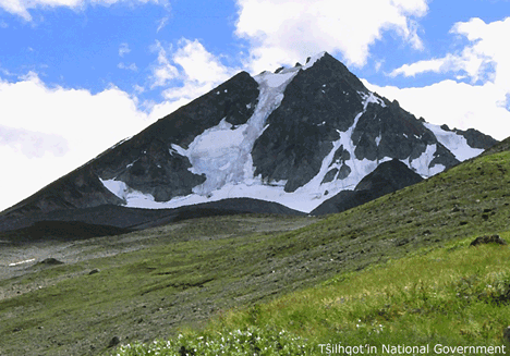
| Feature Type: | Mountain - Mass of land prominently elevated above the surrounding terrain, bounded by steep slopes and rising to a summit and/or peaks. |
| Status: | Not official |
| Other Names: | Tŝ'ilʔoŝOfficial |
| Relative Location: | E side of Tŝilhqox Biny (lake) S of the Nemaiah Valley, Lillooet Land District |
| Latitude-Longitude: | 51°22'20"N, 123°51'48"W at the approximate centre of this feature. |
| Datum: | WGS84 |
| NTS Map: | 92O/5 |
|
Origin Notes and History:
|
"Mount Tatlow" adopted 26 June 1911 on Ottawa file OBF 0024, as submitted 23 June 1910 by BCLS, Vancouver. Name changed 11 March 2019 to Tŝ'ilʔoŝ as recommended by Tŝilhqot’in National Government as Tŝ'ilʔoŝ is the Tŝilhqot’in name for this mountain and supported by the Cariboo Regional District, BC Parks, Avalanche Canda, and Recreation Sites and Trails. Source: BC place name cards, or correspondence to/from BC's Chief Geographer or BC Geographical Names Office |
|
Named in June 1910 by Sidney Williams, BCLS, upon his return from surveying the Chilko Lake area, after the late Hon. Captain Robert Garnet Tatlow, former finance minister who had died earlier that year. Tatlow was born 6 September 1855 at Scarva, County Down, Ireland; educated at Cheltenham, England, and emigrated to Canada at an unknown date; Captain of the First Prince of Wales Regiment, Montreal, then attached to Vancouver's 'B' Battery, Royal Canadian Artillery [dates not cited]; a professional broker and chairman of Vancouver Parks Board for 8 years; married E.M. Cambie, the daughter of prominent CPR official Henry J. Cambie, 30 April 1893; unsuccessful candidate in the provincial election, 1894; elected to the legislative assembly to represent the Vancouver riding in 1900; re-elected 1903 and appointed June 1903 as Minister of Finance and Agriculture in the newly-elected McBride government; lost his seat in the 1909 election; killed in Victoria 11 April 1910, when his horse bolted, throwing him from his carriage. Tatlow (municipal) Park in the Kitsilano neighbourhood of Vancouver is named after the same family. Source: BC place name cards, or correspondence to/from BC's Chief Geographer or BC Geographical Names Office |
|
Identified as Ts'il?os in The Nemiah Declaration, 23 August 1989, by the Tsilqot'in People of Xeni, a.k.a. Nemiah Valley Indian Band. Identified as Mount Tatlo, and positioned north of the Nemiah Valley, in land claims maps filed 2004-05. Source: BC place name cards, or correspondence to/from BC's Chief Geographer or BC Geographical Names Office |
|
The traditional name is Tsy-los [spelled variously through the years; modern preferred spelling is Ts^'il?os.] Ts^'il?os was a man, turned to stone when the world began; he watches over the Xeni people, taking care of them and shouldering their worries and concerns. [see also "Nemiah: the Unconquered Country" by Terry Glavin et at; New Star Books, Vancouver; 1992.] Source: BC place name cards, or correspondence to/from BC's Chief Geographer or BC Geographical Names Office |