| Language of origin | English language |
| Feature Type: | Mount - Variation of Mountain: Mass of land prominently elevated above the surrounding terrain, bounded by steep slopes and rising to a summit and/or peaks. ["Mount" preceding the name usually indicates that the feature is named after a person.] |
| Status: | Not official |
| Other Names: | K'iyán MountainOfficial |
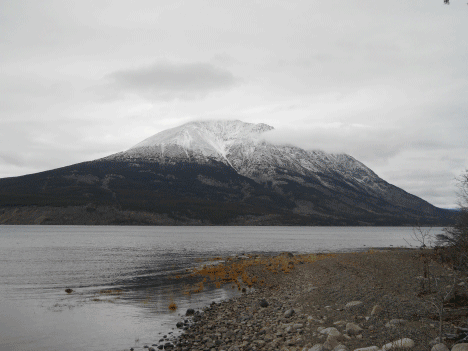
| Relative Location: | W side of Atlin Lake, W of Mount Hitchcock and Black Mountain, NW of Atlin (community), Cassiar Land District |
| Latitude-Longitude: | 59°56'26"N, 133°54'02"W at the approximate centre of this feature. |
| Datum: | WGS84 |
| NTS Map: | 104N/13 |
|
Origin Notes and History:
|
Mount Minto adopted in the 18th Report of the Geographic Board of Canada, 31 March 1924, as labelled on Geological Survey sheet 742, Atlin Mining District, 1902. Re-approved 6 May 1947 on 104NW, and 4 October 1951 on 104N. Official name changed 22 March 2023 to K’iyán Mountain on 104N/13 as requested by Taku River Tlingit First Nation. K’iyán is the traditional and ancestral Tlingit name. Source: BC place name cards, or correspondence to/from BC's Chief Geographer or BC Geographical Names Office |
|
Named in 1899 by J.C.Gwillim, Geological Survey of Canada, after Lord Minto, Governor General of Canada, 1898-1904. Source: BC place name cards, or correspondence to/from BC's Chief Geographer or BC Geographical Names Office |
|
The Tlingit name for this mountain is K’iyán Mountain. (Advice from Taku River Tlingit First Nation, 2016.) Source: BC place name cards & correspondence, and/or research by BC Chief Geographer & Geographical Names Office staff. |
|
Known to the miners as Jubilee Mountains. (J.C.Gwillim, Geological Survey of Canada, 1899, Ottawa file OBF 0002). Source: Canadian Geographical Names Database, Ottawa |