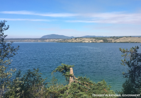
Tatl'ah (Tatla Lake)
[Ta-tlah]
| Language of origin | Athabaskan-Eyak-Tlingit, Na-Dene language family Tŝilhqot’in language |
| Feature Type: | Lake - Inland body of standing water. |
| Status: | Not official |
| Other Names: | Tatl'ah, Tatla LakeOfficial |
| Relative Location: | Expansion of Tatla Lake Creek, N of Telhiqox Biny (lake), Range 2 Coast Land District |
| Latitude-Longitude: | 51°58'55"N, 124°25'15"W at the approximate centre of this feature. |
| Datum: | WGS84 |
| NTS Map: | 92N/16 |
| Related Maps: |
92N/15 92N/16 93C/1 |
|
Origin Notes and History:
|
Tatla Lake was adopted 31 March 1924 in the 18th Report of the Geographic Board of Canada, as labelled on BC Lands Map 1G, 1916. Source: BC place name cards & correspondence, and/or research by BC Chief Geographer & Geographical Names Office staff. |
|
"Tatl'ah" is a Tŝilhqot’in name that roughly translates to "lake bay," referring to the shape at the west end of the lake. This is the name of the lake and the surrounding area. This lake is also known as "Tatl’ah Biny" (advice from Tŝilhqot’in National Government, 2019). Source: included with note |
|
The name comes from the Carrier word meaning 'at the end of the lake.' Source: Akrigg, Helen B. and Akrigg, G.P.V; "1001 British Columbia Place Names"; Discovery Press, Vancouver 1969, 1970, 1973. |