| Language of origin | Athabaskan-Eyak-Tlingit, Na-Dene language family Tlingit language |
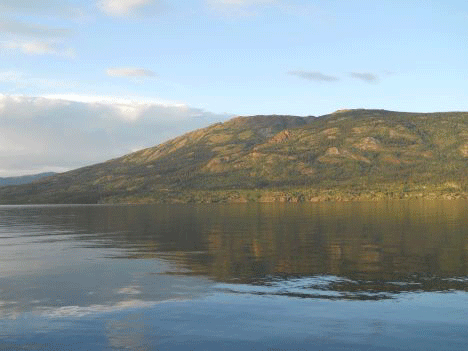
| Feature Type: | Mountain - Mass of land prominently elevated above the surrounding terrain, bounded by steep slopes and rising to a summit and/or peaks. |
| Status: | Official |
| Other Names: | Monarch Mountain |
| Name Authority: | BC Geographical Names Office |
| Relative Location: | E side of Atlin Lake, Just SE of Atlin, Cassiar Land District |
| Tags: | Indigenous |
| Latitude-Longitude: | 59°32'49"N, 133°36'42"W at the approximate centre of this feature. |
| Datum: | WGS84 |
| NTS Map: | 104N/12 |
|
Origin Notes and History:
|
"Monarch Mountain" adopted 4 December 1958 on 104N. A X̲eegí Deiyí Shaa made the official name 22 March 2023 on 104N/12, as requested by Taku River Tlingit First Nation. A X̲eegí Deiyí Shaa is a traditional and ancestral Tlingit name. Source: BC place name cards & correspondence, and/or research by BC Chief Geographer & Geographical Names Office staff. |
|
A X̲eegí Deiyí Shaa is the Tlingit name for this mountain, which translates to “Shoulder trail mountain”. The name references a cultural feature of the mountain, the Taku River Tlingit historic trail in the shape of a shoulder bone, Elder Jackie Williams said “men and women would use different trails and since there were two trails and people have two shoulders they called this trail A Xeegi Deiyi.” (Advice from Taku River Tlingit First Nation, 2016) Source: included with note |
|
For more information, please visit the Taku River Place Names website: http://trt.geolive.ca/map.html. Source: included with note |