| Language of origin | Tsimshianic language family Nisg̲a’a language |
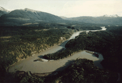
| Feature Type: | Fishing Site - A section in a watercourse or waterbody where there is good fishing, or was historically used for fishing |
| Status: | Official |
| Name Authority: | BC Geographical Names Office |
| Relative Location: | In Nass River, just above New Aiyansh, Cassiar Land District |
| Tags: | Indigenous |
| Latitude-Longitude: | 55°17'45"N, 129°04'04"W at the approximate centre of this feature. |
| Datum: | WGS84 |
| NTS Map: | 103P/6 |
|
Origin Notes and History:
|
Ts'im Anwiihlist (Fishing Site) adopted per Nisga'a Treaty, Appendix F-3, effective 11 May 2000, referring to the site in the river near Gitlaxksiip, an old or former village site. Source: BC place name cards, or correspondence to/from BC's Chief Geographer or BC Geographical Names Office |
|
Ts'im Anwiihlist means "inside the place of the big (oblong) dipnet". Though Ts'im Anwiihlist is part of the territory of a Sin'oogit/chief and his Wilp....it is also a common fishing and food gathering place for [all] the Nisga'a. Ts'im Anwiihlist is a migration spot for salmon. Ts'im Anwiihlist is also a Txeemsim landmark. As Txeemsim, the Grandfather of the Nisga'a, was walking down and creating the river Lisims (Nass River), a ghost whistled in his face when he reached this spot. This made Txeesim turn around and walk back momentarily, and then he turned around again to continue downstream. This accounts for the bend in the river at Ts'im Anwiihlist. It was also here where Txeemsim taught our ancestors how to make a dipnet; the bend in the river is also likened to the hook used to [pull] up the dipnet from the river. Source: Nisga'a Tribal Council / Ayuukhl Nisga'a Department, Aiyansh BC |