

Snug Basin
| Feature Type: | Basin (4) - A water feature similar to a cove or bay. |
| Status: | Official |
| Other Names: | 'ami'q |
| Name Authority: | BC Geographical Names Office |
| Relative Location: | Extends NE from head of Uchucklesit Inlet, N side of lower Alberni Inlet, Clayoquot Land District |
| Latitude-Longitude: | 49°01'33"N, 125°01'45"W at the approximate centre of this feature. |
| Datum: | WGS84 |
| NTS Map: | 92F/3 |
|
Origin Notes and History:
|
Adopted 13 August 1945 on C.3609, as labelled on British Admiralty Charts from 1861, and BC Lands' map 2A, 1913 et seq; a well-established local name according to Hydrographic Service. Source: BC place name cards, files, correspondence and/or research by BC Chief Geographer/Geographical Names Office. |
|
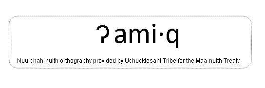
The Uchucklesaht name is ?ami·q (pronounced am MEEK), meaning "horse clam(s), referring to a harvesting location where a small creek flows into the head of the basin. (Uchucklesaht Tribe, December 2010) An image of the written name shows the preferred orthography. Source: included with note |