| Feature Type: | Peak (2) - Summit of a mountain or hill, or the mountain or hill itself. |
| Status: | Official |
| Name Authority: | BC Geographical Names Office |
| Relative Location: | On BC-Alberta boundary at N end Yoho National Park, Kootenay Land District |
| Latitude-Longitude: | 51°37'39"N, 116°30'09"W at the approximate centre of this feature. |
| Datum: | WGS84 |
| NTS Map: | 82N/10 |
| Related Maps: |
82N/10 82N/9 |
|
Origin Notes and History:
|
Adopted the 15th Report of the Geographic Board of Canada, 31 March 1917, as labelled on BC-Alberta boundary sheet #17. Source: BC place name cards, or correspondence to/from BC's Chief Geographer or BC Geographical Names Office |
|
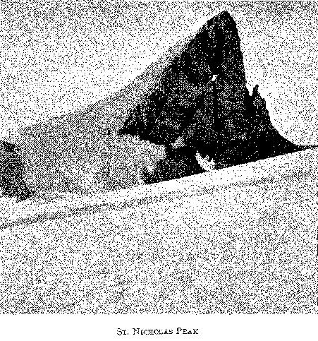
"For a rock formation like Santa Claus." Source: 15th Report of the Geographic Board of Canada, 31 March 1917 (supplement to the Annual Report of the Dept of the Interior, 1917, Ottawa) |
|
"The route from Yoho Glacier is over the icefield around the north end of Mt. Gordon and descends the more southerly of the two icefalls of Bow Glacier; in doing so it passes close to a somewhat remarkable peak on the east side of the watershed which owing to an outstanding gendarme of rock that closely resembles the patron saint of Christmas time, has been named St. Nicholas Peak; its altitude is 9616 ft." (BC-Alberta Boundary Report, Part II, 1917-1921, pp 10-11 with photograph) Source: included with note |