| Language of origin | English language |
| Feature Type: | Mountain - Mass of land prominently elevated above the surrounding terrain, bounded by steep slopes and rising to a summit and/or peaks. |
| Status: | Official |
| Name Authority: | BC Geographical Names Office |
| Relative Location: | On BC-Alberta boundary, N of Mount Joffre in Height of the Rockies Provincial Park E of Invermere, Kootenay Land District |
| Latitude-Longitude: | 50°34'07"N, 115°14'17"W at the approximate centre of this feature. |
| Datum: | WGS84 |
| NTS Map: | 82J/11 |
|
Origin Notes and History:
|
Mount Warrior Adopted 23 February 1918 by the Geographic Board of Canada, as labelled on BC-Alberta Boundary sheet #10, surveyed in 1916, published in 1917. Form of name changed to Warrior Mountain 3 October 1957 on 82 J. Source: BC place name cards, or correspondence to/from BC's Chief Geographer or BC Geographical Names Office |
|
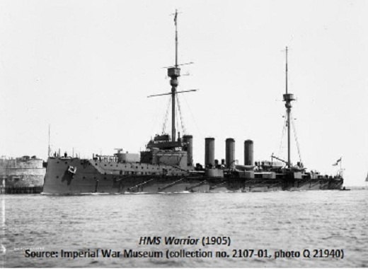
Named by interprovincial boundary surveyors "after a cruiser in Jutland battle, 31 May 1916." (excerpt from The Canada Gazette, 23 February 1918.) The British armoured cruiser HMS Warrior was heavily damaged by German shells during the Battle of Jutland, 31 May - 1 June 1916, but she was withdrawn to safety and abandoned - her surviving crew having been taken aboard a tender. Warrior foundered and sank in a rising sea later that day. Source: BC place name cards, or correspondence to/from BC's Chief Geographer or BC Geographical Names Office |